Lake Pend Oreille tour destinations
At 43 miles long, 6 miles wide and with 111 miles of shoreline, Lake Pend Oreille offers many great boat excursions.
If you don’t own your own boat, rentals of sail, paddle and power vessels are offered at a number of marinas in towns around the lake. See the Boat Rentals & Service page for leads to marinas closest to the departure point you prefer, or check the Super Directory under Marinas & Boating Services.
Boat charters, which include the captain and crew to handle actually piloting the boat, are also available. Or if you’re more interested in experiencing the lake in the intimacy of a paddle craft such as a kayak or canoe, several companies offer rentals or guided tours. Check the Boat Rentals & Service page for resources, or click to go to Tour Guides & Outfitters in the Super Directory.
Below are some good lake destinations for boaters, listed in order from the south end of the lake and moving north and then east.
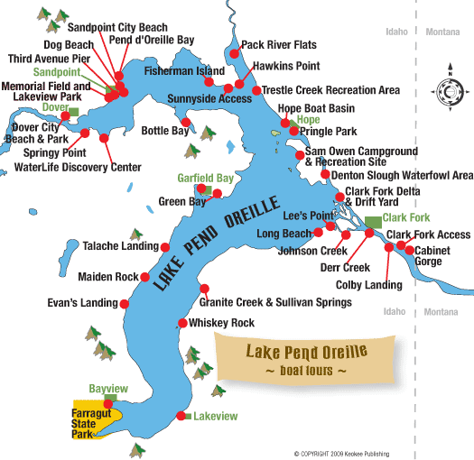
Buttonhook Bay
The very southern tip of the lake adjacent to Bayview has a bay named after the hook used to lace up old fashioned boots, the buttonhook. Scenic Buttonhook Bay offers very well-protected waters with several public boat docks and slips. Boats can dock or anchor overnight in the shallow waters. On shore at Farragut State Park, a foot trail leads hikers up above the bay for excellent views across the lake. Going the opposite way takes you to Beaver Bay, a developed swimming area. North of Beaver Bay, there is another public launch area with picnic sites called Eagle Boat Launch.
Bernard Peak
Mountain goats thrive at Bernard Peak near Echo Bay after being planted there in the early 1960s from Snow Peak in the North Fork of the Clearwater. Boaters may drive to the shore where the point juts out into the lake to spot the white beasts in their precipitous home. You’re quite likely to see at least some of the 30 or so that live on the cliffs. Spotting scopes are found across the lake at the Willow Day Use Area inside Farragut State Park.
Lakeview
Departing from the Eagle Boat Launch at Farragut State Park or from Bayview, it’s an easy trip across the lake to Lakeview, where the county maintains a public dock flanked by private property. Lakeview is surrounded by abandoned limestone mines. Much of the town is situated on a bench well above the lake. Three miles above Lakeview is the Happy Hermit Resort that operates year-round, catering to snowmobile enthusiasts in the winter. Lakeview is also accessible by car on Forest Service Road 278. See Lake Drives.
Whiskey Rock
At Whiskey Rock Bay, boaters can pull into a protected cove where they can enjoy swimming or hiking around the area, or even camping. During summer’s high pool, the rock itself is pretty tough to spot: It’s submerged during high water and marked with a navigation light.
Cunninghams Castle
About a mile south of Whiskey Rock, is the old site of Cunninghams Castle. Rumored to be the site of a former bordello and the headquarters for whiskey runs during Prohibition, the site is empty now. Old-timers can remember seeing the castle-like structure back in the 1950s. However after the Forest Service acquired the property, it was burned down. The site is also accessible by car on Forest Service Road 278. See Lake Drives.
Maiden Rock
Maiden Rock is an enormous block of granite jutting out into the lake about two-thirds of the way down the west shore of the lake’s south arm. Boats may pull up on the beach, but there are no docks. There is a Forest Service recreation site with picnic tables and camping. Hikers can scramble to the top of Maiden Rock for a fantastic view across the lake. Maiden Creek Trail No. 321 accesses Maiden Rock by foot, horseback or motorbikes.
Garfield Bay
From Garfield Bay, boaters can cross the broad reach directly across the lake to the foot of the Monarchs on the opposing shore, to Windy or Indian points. Or head northeast to nearby Green Bay, where there’s a campground and swimming beach. Look for a rope swing on the rocky point at the west end of Green Bay. From there you can go farther northeast to Mineral Point and Anderson Point, passing several bays and Picard Point on the way. Or conversely, head south, toward the more distant Talache Landing or Maiden Rock.
Contest Point
A good excursion from Sandpoint proper is south and east across the lake to Contest Point. From here you can cruise into long narrow Bottle Bay, with Bottle Bay Resort (208-263-5916) a possible destination. If you venture a few miles north and east back across the bay you can cruise by tiny Fisherman Island, a day-use only area managed by Idaho Fish and Game, off the Sunnyside Peninsula before returning to Sandpoint, completing what’s known as the “Boaters Triangle.”
Long Bridge to Dover
Though not technically the lake, the water west of the Long Bridge to Dover is often considered Lake Pend Oreille. Boaters can depart from Memorial Field, Dover Bay or Springy Point to explore downriver as far as Albeni Falls Dam. A good stop along the way would be Riley Creek Recreation Area at Laclede on the Pend Oreille River, where there’s a swimming beach, playground, campground and walking trail.
Sunnyside Access and Hawkins Point
Sunnyside Access and Hawkins Point are suitable for launching small boats for fishing around Sunnyside Peninsula or in the Pack River Flats south of Idaho State Highway 200.
Pack River Wildlife Management Area
Launching at the Pack River Flats, boaters can explore the Pack River Wildlife Management Area, designated as a no-wake zone. Small car-top fishing boats may head downstream of Highway 200 to the railroad trestle, while only non-motorized craft are allowed upstream of the highway.
Hope Area
In the Hope area east of Sandpoint, boaters can tour around several small islands including Warren, Cottage, Pearl and Memaloose. Memaloose was once an Indian burial ground and sacred site. The islands are private, so don’t go ashore without permission.
Monarch Mountains
A trip south across the lake from Hope will take boaters to the majestic, magnificent Monarch Mountains. Starting at the navigation lights at Lee’s Point near the mouth of the Clark Fork River, the shore below the Monarchs stretches across an area known as “Long Beach.” Some people camp along this stretch managed by the Forest Service. Although the campsites are primitive, there are a couple of vault toilets. A fire storm in 1991 burned much of the Monarchs. Farther east is Deadman Point, Indian Point and Windy Point.
Dover City Beach and Park
Managed by the City of Dover, this is a day-use, no-fee area that is adjacent to the new Dover Bay waterfront community and to the west of its marina.
What’s it like?
Rocky Point is a rugged spit of land at the eastern edge of this area and Tank Hill is the small, hump-like hill that rises along the shore at Dover Point. Much of the inland area here is wetlands. In 2005, building began on the Dover Bay residential waterfront community that transformed the old mill site, 285 acres and over a mile of shoreline, into a major development with a 274-slip marina, hundreds of homesites, condos, bungalows for vacation rental, common open space, boardwalk, a waterfront village area with a café, market and fitness center, and nine miles of paved trails that connect to the Sandpoint-Dover Community Trail.
The public access area is the Dover City Beach and Park, sandwiched by the resort and located west of the marina at the end of a narrow sandy stretch of land next to Brown’s Bay Inlet. The public can moor at the marina for access to the resort’s restaurant and shops. Boat gas is available at the Dover Bay marina dock as are canoe and kayak rentals. The Dover Bay resort set aside Verwolf Vista Park at the top of Tank Hill and maintains a public hiking trail leading to it. The Balto Dog Park opened in 2009 and features a boardwalk for diving dogs, fire hydrants and a wash-down area with a solar-heated hose system.
Facilities: dock, picnic tables, benches, sandy beach, paved bike trails, restrooms, dog park
Activities: boating, swimming, paddling, picnicking, fishing, walking, biking
How to get here: Dover is three and a half miles west of downtown Sandpoint along U.S. Highway 2. Turn south at the Dover Bay turnoff, go west past the Discovery Center on Railroad Avenue to Dover Bay Way and turn left. Follow to Lakeshore Drive and turn right. Dover City Beach and Park is at end of this road next to City Hall.
War Memorial Field & Lakeview Park
Bonner County manages the boat launch and docks, and the adjacent park is maintained by the City of Sandpoint. Both are day-use only, with no fees. But the field is also home to nighttime athletic activities – baseball and football – for Sandpoint High School’s “Bulldogs” and also to the evening concerts produced by the Festival at Sandpoint every August.
What’s it like?
This is one of Sandpoint’s most popular public areas. The ample parking lot to the east of the ball field is typically crowded with cars and boat trailers all summer long. The boat launch that extends from there is paved and there are two docks for boats. Kayakers and canoeists sometimes put in here and paddle downstream to Dover, but this is a busy powerboat area, so be aware. There’s a gravel bike and walking path along the riverbank that takes you to Lakeview Park and the arboretum. A covered picnic area near the boat launch has two tables. A recent upgrading to the boat launch area in 2008 includes placement of benches along the bank.
But the most meaningful upgrade to the Memorial Field boat launch deserves special recognition. It is a project that was spearheaded by the late Gary Parker that brought together several government agencies and conservation groups. Gary’s vision was to protect Lake Pend Oreille’s water quality in a two-fold way. First, runoff from the concrete boat ramp and adjacent parking lot was diverted into a series of adjacent swales inoculated with a fungus that organically digests water pollutants such as oil and gasoline, rendering them harmless. Second, more than 650 riparian plants and shrubs, many of them native to our area, were planted along 500 feet of riverbank to demonstrate the importance of a vegetative buffer from the water – a great ecological improvement over a grass lawn that usually requires chemical fertilizers and herbicides to keep it green. Gary’s contribution to our lake will be a model of sustainable resource management throughout the region for many generations to come.
To the west of the ball field bleachers is Lakeview Park, the Native Plant Arboretum and Bonner County Historical Museum. There are tennis courts and several picnic tables, covered group shelter and a large grassy area beneath towering ponderosa pines to enjoy several family activities. Consider a game of catch, frisbee or tag – fun! Paths through the park are paved, making it easy for moms with strollers or for kids on bikes. The Bonner County Historical Museum is located on the park grounds – just look for the train caboose or large waterwheel out in front of the building. The Kinnikinnick Chapter of the Idaho Native Plant Society manages the arboretum surrounding the museum, which is a good place to learn about the native flora of the countryside surrounding Lake Pend Oreille. There are also several pairs of nesting osprey in this area, and it is thrilling to watch an adult bird spear a large fish with its talons and bring it back to the nest to feed the fledglings.
Facilities: concrete boat ramp, two docks, covered picnic tables, benches, gravel and paved paths, tennis courts, basketball court, playground, group shelter, restrooms, arboretum, and museum and gift shop
Activities: boating, picnicking, fishing, biking, walking, historical tours, wildlife viewing, and learning about native flora and trees
How to get here: The parking areas, boat launch area, and park and museum is accessed from town via Boyer Avenue (runs north and south) or Ontario Street (runs east and west), both accessible from U.S. Highway 2 in Sandpoint. There is ample parking for cars including those with boat trailers to the east of Memorial Field. Another parking lot is located on the west end of the park at the museum and arboretum grounds. It is accessed from Ella Avenue off of Ontario Street. Additional parking is along residential streets.
Third Avenue Pier
Lorem ipsum dolor sit amet, consectetur adipiscing elit. Ut elit tellus, luctus nec ullamcorper mattis, pulvinar dapibus leo.
Dog Beach
Lorem ipsum dolor sit amet, consectetur adipiscing elit. Ut elit tellus, luctus nec ullamcorper mattis, pulvinar dapibus leo.
Sandpoint City Beach
Lorem ipsum dolor sit amet, consectetur adipiscing elit. Ut elit tellus, luctus nec ullamcorper mattis, pulvinar dapibus leo.
Pend d’Oreille Bay
Lorem ipsum dolor sit amet, consectetur adipiscing elit. Ut elit tellus, luctus nec ullamcorper mattis, pulvinar dapibus leo.
Fisherman Island
Lorem ipsum dolor sit amet, consectetur adipiscing elit. Ut elit tellus, luctus nec ullamcorper mattis, pulvinar dapibus leo.
Sunnyside Access
Lorem ipsum dolor sit amet, consectetur adipiscing elit. Ut elit tellus, luctus nec ullamcorper mattis, pulvinar dapibus leo.
Hawkins Point
Lorem ipsum dolor sit amet, consectetur adipiscing elit. Ut elit tellus, luctus nec ullamcorper mattis, pulvinar dapibus leo.
Pack River Flats
Lorem ipsum dolor sit amet, consectetur adipiscing elit. Ut elit tellus, luctus nec ullamcorper mattis, pulvinar dapibus leo.
Trestle Creek Recreation Area
Lorem ipsum dolor sit amet, consectetur adipiscing elit. Ut elit tellus, luctus nec ullamcorper mattis, pulvinar dapibus leo.
Hope Boat Basin
Lorem ipsum dolor sit amet, consectetur adipiscing elit. Ut elit tellus, luctus nec ullamcorper mattis, pulvinar dapibus leo.
Pringle Park
Lorem ipsum dolor sit amet, consectetur adipiscing elit. Ut elit tellus, luctus nec ullamcorper mattis, pulvinar dapibus leo.
Sam Owen Campground & Recreation Area
Lorem ipsum dolor sit amet, consectetur adipiscing elit. Ut elit tellus, luctus nec ullamcorper mattis, pulvinar dapibus leo.
Denton Slough Waterfowl Area
Lorem ipsum dolor sit amet, consectetur adipiscing elit. Ut elit tellus, luctus nec ullamcorper mattis, pulvinar dapibus leo.
Clark Fork Delta and Drift Yard
Lorem ipsum dolor sit amet, consectetur adipiscing elit. Ut elit tellus, luctus nec ullamcorper mattis, pulvinar dapibus leo.
Johnson Creek Access Area
Lorem ipsum dolor sit amet, consectetur adipiscing elit. Ut elit tellus, luctus nec ullamcorper mattis, pulvinar dapibus leo.
Lee’s Point
Lorem ipsum dolor sit amet, consectetur adipiscing elit. Ut elit tellus, luctus nec ullamcorper mattis, pulvinar dapibus leo.
Long Beach, Green Monarch Escarpment
Lorem ipsum dolor sit amet, consectetur adipiscing elit. Ut elit tellus, luctus nec ullamcorper mattis, pulvinar dapibus leo.
Clark Fork
Lorem ipsum dolor sit amet, consectetur adipiscing elit. Ut elit tellus, luctus nec ullamcorper mattis, pulvinar dapibus leo.