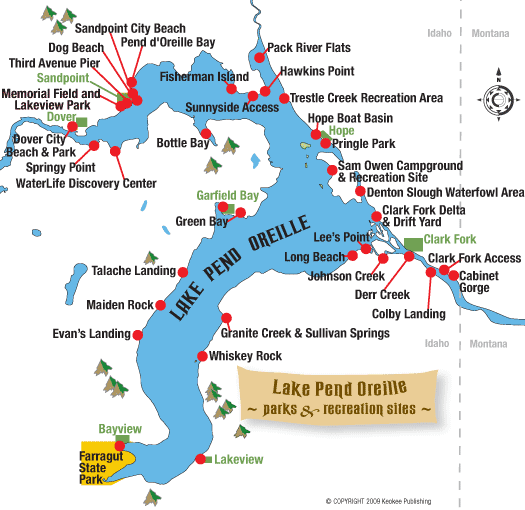
Lake Pend Oreille Parks and Public Access Sites
Lake Pend Oreille has plenty of parks, boat launches, picnic sites and other attractions and facilities. Here is a guide to public parks and public access sites on Lake Pend Oreille, starting with the south arm of the lake and moving north, then going sideways west to Dover, back to Sandpoint and then east around the lake, including up the Clark Fork to Cabinet Gorge.
You can click on the park name on the map at right to jump to its description below.
Farragut State Park
This is a fee area managed by State of Idaho Parks and Recreation.
What’s it like?
It was named for Admiral David Farragut, the first Navy admiral appointed by Congress for leadership during the Civil War, who was known for his famous cry of “Damn the torpedoes! Full steam ahead!” This once-expansive, inland U.S. naval base was the second-largest naval training facility in the world. Farragut was integral to the nation’s World War II effort, having trained almost 300,000 sailors.
Acquired by the state in 1965, today Farragut is one of the premier state parks in Idaho. It encompasses 4,000 acres of pine forests, open meadows and spectacular sandy beaches and lakefront. Besides being one of the largest camping areas in northern Idaho, it offers facilities for a variety of year-round recreational opportunities and is a popular cross-country skiing area in the winter. Year-round attractions include a visitor center, the Brig Museum, which tells its Naval history, and an interpretive walking tour of the park. Part of the park is co-owned by Idaho Fish and Game and is managed as a wildlife refuge. Farragut Park has hosted National Girl Scout and Boy Scout Jamborees over the years, giving more than 130,000 scouts the experience of a lifetime.
Boaters, sailors and paddlers enjoy Farragut because of its sheltered location on the lake. The high, steep cliffs tumbling off Bernard Peak protect the two bays – Scenic and Idlewilde – that anchor the south end of Lake Pend Oreille. Eagle Boat Landing is a large, modern facility that accommodates most types of marine vessels. It is located just south of Blackwell Point on the west side of Idlewilde Bay.
Hiking, bicycling and mountain biking opportunities in the park are extensive, ranging from easy excursions of less than a mile to all-day adventures of 20 miles or more. Detailed maps are recommended and available for purchase at the park visitor center. The most popular trails include: Squirrel Cache Nature Trail – a self-guided interpretive trail (a portion of the trail was originally a horse and wagon route in the 1860s); Shoreline Trail that winds along the shoreline from the Blackwell Point Viewpoint south to Eagle Boat Landing, past Beaver Bay Swimming Area, around Buttonhook Bay, and then upland through a pleasant forest environment where it joins the Highpoint Trail – a three-mile trail that affords hikers a variety of options and terrain including spectacular vistas of the lake. Beaver Bay is one of the nicest areas for swimming on the lake.
Horseback riders and llama users are also welcome at Farragut but are restricted to the trails north of Highway 54. The newly developed Corral Area provides equestrians and llama users easy access to these trails, which are also accessible to hikers and bikers. The Corral Area, located just north of the Thimbleberry Group Area and east of park headquarters, is made up of two public access areas of temporary holding stalls. Here you’ll find ample parking, overnight campsites, hitching posts and a watering trough. But beware if your horse spooks at loud noises: The park’s shooting range is also in this area. Future plans for this area include a basic riding arena, shelter, equestrian experience course and improved trail linkage.
The Sunrise and Willow day use areas at Farragut offer picnic shelters, tables and lakeview cabins that can be reserved for gatherings and events. The Willow Day Use Area also has coin-operated spotting scopes for viewing mountain goats on the Bernard Peak cliffs across Idlewilde Bay.
Farragut State Park offers lots of camping choices. There are nearly 200 overnight sites at five campgrounds, plus two group camp areas. Overnight fees vary, and trailers and RVs up to 32-feet long can be accommodated. Campgrounds offer boat ramps, docks, dump stations, flush toilets, hot showers and potable water. For reservations, call 208-683-2425 or log onto www.reserveamerica.com.
At the western end of the park, just past the visitor center, is a large, open area for flying model airplanes. One of the newest attractions at Farragut, an 18-hole disc golf course is located at the east end of the park near the Locust Grove Picnic Area and water tower. The course offers hours of challenging fun in a forest of mixed-age trees. Keep a close eye on your flying disc, though, as it is easy to lose in the summer foliage.
Farragut State Park is one of the best places in northern Idaho for family-centered outdoor adventure. Come for an afternoon picnic and swim, or camp for several days and explore the surroundings. For more information about this park, go online to www.idahoparks.org and search for Farragut.
- Facilities: concrete boat ramp, docks, fish-cleaning station, group picnic areas, group and individual campgrounds, amphitheater, picnic tables, restrooms, hot showers, dump station, RV hookups, sandy beach, horseshoe pits, volleyball courts, drinking water; hiking, horseback and biking trails; photographic viewpoints, coin-operated spotting scopes, shooting range, model aircraft field, disc golf course, visitor center and Brig Museum
- Activities: camping, boating, sailing, canoeing, kayaking, scuba diving, fishing, swimming, picnicking, hiking, biking, horseback riding, wildlife viewing, horseshoe and volleyball games, model aircraft flying, target shooting, disc golf, and museum tour
- How to get here: From Athol on U.S. Highway 95, turn west on Idaho State Highway 54 and travel four miles to the main entrance just past the traffic circle. The visitor center is on your right and has maps, campground information and interactive displays about the wildlife and geology of the park. Farragut State Park is open year-round.
Bayview
A free, public boat launching facility managed by Kootenai County occupies a narrow slot leading to the water in the center of Bayview, next to Boileau’s Resort.
What’s it like?
Located on Scenic Bay next door to Farragut State Park, this is the gateway for Lake Pend Oreille for those approaching from the Spokane-Coeur d’Alene area. In fact it was Spokane entrepreneurs who built it as a resort community, welcoming its first permanent residents in 1910. There are numerous private marinas, restaurants, shops and other amenities available, including marine tours and charters. Private property crowds this launch site and parking is limited.
Bayview also has something familiar to visitors from the Puget Sound area – old limestone kilns. A cement industry flourished in the area in the early decades of the 20th century, and lime was shipped first by barge north to railheads at Hope and Sandpoint, and then directly by rail to Spokane. You can view the ruins of the kilns from Scenic Bay Marina.
This lakeside community is home to hundreds of sailboats, and you’ll see a lot of float homes and houseboats moored in the marinas, too. They have been a part of the Bayview experience for generations. This is one of the most popular boating and sailing areas on the lake.
The residents of Bayview host a major annual event that draws crowds of tourists from around the region – Bayview Daze. It’s a community celebration that happens around July Fourth and culminates in a spectacular fireworks display over the water.
The U.S. Navy has maintained an acoustic research facility in Bayview since the 1950s, including work on the Sea Wolf submarine. One-fifth scale models of the Navy’s equipment are tested on Lake Pend Oreille, but the newest facet of the Navy’s research is surface water warfare testing with a 133-foot, quarter-scale model of a destroyer that launched in 2005. The Sea Jet operates on the lake between Bayview and Garfield Bay.
- Facilities: concrete boat ramp; public dock; gas, rope crane, marine supplies and repair at private marinas; sailboat, fishing boat, houseboat and canoe rentals and moorage; boat cruises, tours and charters; restaurants, groceries, retail shops and lodging
- Activities: sailing, boating, paddling, fishing, houseboat camping, picnicking, wildlife viewing, scuba diving
- How to get here: Take Idaho State Highway 54 east from U.S. Highway 95 at Athol and travel six miles, passing through Farragut State Park to reach Bayview at the northeast corner of the park.
Lakeview
This area offers free public facilities managed by Bonner County. Tying boats up overnight on docks is OK if not near the gravel launch, but picnicking on docks is not allowed.
What’s it like?
Flanked by private property, the small community of Lakeview is surrounded by abandoned limestone mines. It is a serene and pleasant place, and surprisingly much of the town is situated on a bench well above the lake with the majority of houses lacking a view of the lake. Three miles above Lakeview is the Happy Hermit Resort that operates year-round, catering to snowmobile enthusiasts in the winter. There are numerous small beaches from here to Whiskey Rock.
- Facilities: gravel boat ramp, docks, sandy beach, vault toilet
- Activities: boating, fishing, swimming, scuba diving
- How to get here: Follow the Bunco Road No. 332 just over seven miles east to where the pavement ends at a large parking area. From there the road climbs into the mountains south of the lake. Drive another six miles to the junction with Road No. 278, which descends from Road 332. From there, it’s approximately 12 miles to Lakeview. The narrow road down to the lakeshore is steep and rutted. There is parking for only three or four vehicles. See Lake Drives.
Whiskey Rock
Managed by the U.S. Forest Service, this is a no fee area that has 13 campground sites accessible to small motor homes and travel trailers. Campground limit is 14 days.
What’s it like?
Shaded by big ponderosa pines and Douglas firs, this remote site is a great destination on the lake’s eastern side. The rocky shoreline makes for some interesting exploration along the edge of the lake, while a pleasant grassy area adjoins the beach. It is a picturesque, wooded cove with sweeping views of the lake and its western shores. There is a dock here for boats arriving by water, but there is no public launch ramp. The primitive launch site here is private for use only by Whiskey Rock residents. Car-top boats can access the lake from the gravel beach.
- Facilities: campground (no electrical hookups or large RVs), drinking water, telephone, dock, picnic tables, vault toilets, gravel beach
- Activities: camping, picnicking, boating, fishing, swimming, scuba diving
- How to get here: Road access is from Johnson Creek-Lakeview Road No. 278. The access dirt road to the boat ramp is narrow and rough; large RVs are not recommended because there is only a small turnaround. An approach from the water across the lake at Garfield Bay or from Bayview is the better idea. See Lake Drives. It is also accessible by hiking down Packsaddle Mountain Trail No. 76.
Granite Creek & Sullivan Springs
The fish weir at Sullivan Springs is maintained by Idaho Fish and Game for kokanee reproduction. The dock is managed by Bonner County as a day-use, no-fee area, but tying up to the dock overnight is allowed.
What’s it like?
Mining claims were established here during the 1880s, and a small community sprang up as a result. Today Granite Creek ranks as the most valuable spawning stream on Lake Pend Oreille for several species of fish, especially kokanee. Sullivan Springs is a magnificent, natural spring upstream from the lake about one-half mile. Granite Creek is accessed by water. In late autumn, bald eagles dot the trees along the shoreline and feed on fish that spawn and die.
- Facilities: dock, porta-potty
- Activities: boating, swimming, fishing, scuba diving, wildlife viewing
Evan’s Landing
Managed by the U.S. Forest Service, this is a no-fee area.
What’s it like?
Primitive and remote, this site caters to hikers and boaters and is accessible only by foot or boat. It is a popular area for paddlers kayaking or canoeing south from Talache Landing. Hiking in is along Evan’s Landing Trail No. 64. Sweeping views across the lake toward the Coeur d’Alene Mountains are unmatched from this beach, and the area is often overlooked, especially on busy summer days. The remains of an old cabin are found here.
Between Evan’s Landing and Cape Horn is a narrow bench of land below the Three Sisters Peaks called Grasshopper Point. By some accounts, the lake is well over 1,200 feet deep just offshore. The U.S. Navy maintains an offshore barge just north of here, which is off-limits to the public.
- Facilities: rustic, primitive campsites (spring until late fall), pebble beach, picnic tables, porta-potty
- Activities: camping, picnicking, boating, fishing, swimming, hiking, scuba diving, kayaking, canoeing
- How to get here: About 17 miles south of Sandpoint, Idaho, near milepost 457 turn east onto Blacktail Road (Blacktail Road makes a loop and joins Highway 95 near milepost 457 and near milepost 463). Go 2.6 miles to Little Blacktail Road, turn east again and go another 2.6 miles past one trail sign to East Ridge Road where a second trail sign indicates the way to this trailhead. Take a right on East Ridge Road, go 1/2 mile and turn left onto a short spur road. Proceed to a parking area where the road splits. It will accommodate five to 10 vehicles. The Evan’s Landing Trail No. 64 is a moderate, 2-mile hike one-way.
Maiden Rock
Managed by the U.S. Forest Service, this is a day-use, no-fee area.
What’s it like?
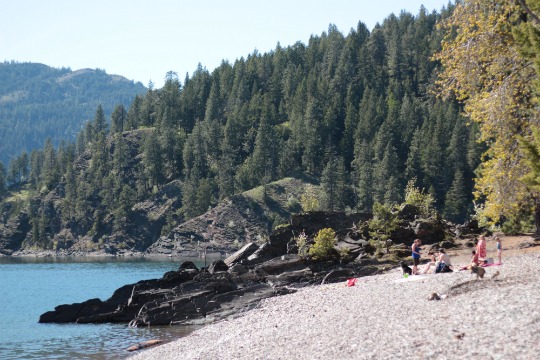
A primitive and remote site, it is accessible only by trail or boat. The area is adjacent to a unique geologic feature on the lake – Maiden Rock, a huge outcropping that drops steeply into the lake next to a beautiful pebble beach. A jagged ridge tumbles from the summit of Blacktail Mountain into the cold waters of the lake near the mouth of Maiden Creek. The last drop-off of several hundred feet is along the angular, stair-step cliffs.
- Facilities: picnic tables, fire pit, stony beach, vault toilet
- Activities: boating, picnicking, fishing, swimming, scuba diving, hiking
- How to get here: From Sandpoint, Idaho, take U.S. Highway 95 south approximately 11 miles to milepost 463. Turn east onto Blacktail Road, which rises at a sharp angle from the highway across from Tri Con Bolt Company (Blacktail Road makes a loop and joins Highway 95 near milepost 457 and near milepost 463). Go 1.5 miles to Butler Creek Road No. 230. Turn left and travel three miles to the trailhead. The parking area will accommodate three to six vehicles. This is a rough and rutted road passing through private property. Maiden Creek Trail No. 321 is a moderate, 2-mile hike one-way.
Talache Landing (Talache Beach)
At the end of Talache Road, a road maintained by Bonner County, is an area that provides a day-use beachfront called Talache Landing. There is limited parking for one or two vehicles along the road. Note that this spot is actually on private property. Forest Service land is north and south of this area.
What’s it like?
This is a popular put-in area for kayakers and canoeists coming from Sandpoint and Sagle. From the water, it’s a short paddle to reach Forest Service public lakefront north of Mirror Creek (the original landing from which iron ore was shipped by barge) or south of Talache Beach, towards Maiden Rock and past several homes. It is also a convenient put-in for those paddlers who would like to try primitive camping on one of the colorful pebble public beaches in either direction. On hot summer days, Talache Beach is also a popular swimming area for local residents and scuba divers in search of treasures from mining days.
- Facilities: mixed rocky, gravel and sand beach, convenient put-in from shore for paddlecraft
- Activities: canoeing, kayaking, fishing, swimming, scuba diving
- How to get here: There is paved access from U.S. Highway 95, five miles south of Sandpoint at the community of Sagle. Turn east on Sagle Road and drive just over a mile. After passing South Sagle Road, go right at a fork on Talache Road, which is a paved road for a ways. Travel about six miles to the end of the road.
Garfield Bay
The recreation site is managed by Bonner County and is a free day-use area, but there are fees for the campground. There are private marinas, campgrounds, lodging, stores and restaurants found here as well.
What’s it like?
When you come driving into Garfield Bay on a sunny summer day, it feels like you are descending into a small fishing village on a seacoast that time has forgotten. The open cove with its marina, boats and rustic homes offer a delightful repose. The modern campground facilities and adjacent beaches, tucked back and protected at the head of the bay with its pleasant green lawn, make it an ideal family destination with plenty of space for relaxing and playing. It is open year-round. The private marina offers boat slips to rent by the hour or day if you come to have dinner or to stay for a few hours to fish or swim. Looking back from the water, Grouse Mountain is to the west and the next landform south is Grouse Mountain Point before Talache Landing.
Garfield Bay is also a well-protected bay for canoeing or kayaking, although as you round the point toward Green Bay it can get choppy. The shoreline is rocky, but there are some nice stony beaches to enjoy swimming and picnicking. Launching from Garfield Bay it is a one- to three-mile one-way paddle to Green Bay depending on where along the shoreline you land.
- Facilities: campground for tents and trailers (up to 22 feet with no hookups), concrete boat ramp, docks, sandy beaches, picnic tables and barbecues, children’s playground, drinking water, vault toilet
- Activities: camping, boating, sailing, swimming, picnicking, paddling, fishing
- How to get here: There is paved access from U.S. Highway 95, five miles south of Sandpoint at the community of Sagle. Turn east on Sagle Road and go 7.2 miles to Garfield Bay Road. Veer right and travel 1.25 miles to the paved parking area. The campground is across the road and is RV-accessible.
Green Bay
Managed by the U.S. Forest Service, this is a no-fee area.
What’s it like?
Though it faces due south into strong winds that often blow up the length of the lake, this is one of the more beautiful places on Lake Pend Oreille’s shore. The water is exceptionally clear and rock outcroppings punctuate the shoreline. Long Point and Mineral Point are landforms on the eastern edge of Green Bay. The entire region – with its lakeside access, cliffs, picturesque shoreline, superb hiking and biking trails, and a sense of solitude even when it’s crowded, make this place a true favorite for locals and visitors alike.
The high bluffs of the Mineral Point Trail overlooking Green Bay offer marvelous views of Lake Pend Oreille. Along the trail is a memorial plaque dedicated to the memory of Brent “Jake” Jacobson, a Forest Service law enforcement officer who gave his life in the line of duty.
Despite the steep access road, Green Bay is worth the extra effort. Spending a few nights camping among the pines near the lakeshore and counting the stars at night, and fishing, hiking or just relaxing during the day is an experience every northern Idaho visitor should have, anytime between snow thaw in spring until late fall. For sailors there are temporary mooring buoys just a little ways off shore.
- Facilities: rustic campsites, picnic tables, barbecue grills, pebble beaches, vault toilets, self-guided interpretative trail, hiking/biking trails, mooring buoys
- Activities: camping, boating, sailing, swimming, picnicking, hiking, biking, fishing, paddling from Garfield Bay
- How to get here: The campground is 16 miles southeast from Sandpoint. From U.S. Highway 95, five miles south of Sandpoint, turn east on Sagle Road and travel 7.2 miles to Garfield Bay Road. Once you reach Garfield Bay, proceed past the county recreation site to the Garfield Bay Cutoff Road. Take it 0.2 mile and turn right on Green Bay Road, then go 1.2 miles to a fork in the road. Go right and descend to Green Bay parking area. This site is also accessible by boat, but there are no docks – only mooring buoys.
Bottle Bay
There are only private beachfront homes and residential lots along the lakeshore northeast from Sandpoint, but there is one privately owned facility whose amenities are available to the public – Bottle Bay Resort and Marina.
What’s it like?
Bottle Bay is a long, bottle-shaped bay that still has many of the lake cabins that were built back in the days of commercial whitefish and kokanee fishing. On the west lip of the bay is Sourdough Point, a private residential area that used to be a winter settlement of fishermen who toughed out the harsh, cold months surviving on sourdough bread and smoked fish. The Bottle Bay Resort and Marina, built by then-commercial fish-processor Bill Zinter, still offers several amenities to the public for year-round enjoyment. Many boaters come from Sandpoint, moor up long enough to enjoy a rainbow trout dinner or glass of wine at the resort’s fine restaurant and lounge, and then cruise back to town. Some folks spend the night, a close-to-home getaway.
Facilities: boat launch for resort patrons, overnight (for fee) moorage, sandy beach, docks, full-service restaurant and lounge, vacation cabin rentals, kayak and canoe rentals, boat fuel
Activities: lodging, boating, sailing, fishing, paddling, swimming, scuba diving
How to get here: About a mile south of Sandpoint’s Long Bridge, turn east at Bottle Bay Road and follow for 11 miles. Look for resort signs on paved road, turn left and down steep hill to water’s edge. The resort is also accessible by boat.
WaterLife Discovery Center
A cooperative project of Idaho Fish and Game, the Idaho Fish and Wildlife Foundation and the local community, which includes several sportsmen groups, this habitat education and interpretive area on the southern bank of the Pend Oreille River is a grassroots work-in-progress that began taking shape in the mid-1990s.
What’s it like?
This self-guided educational center encompasses the historic Sandpoint Fish Hatchery, built in 1909, which is still used as a summer redistribution facility for rainbow trout. An interpretive center for the site features an indoor classroom and interactive exhibits for teaching about the health of aquatic ecosystems. This educational center aims to connect students and families with the natural world and their roles in it. In addition to the opportunity to learn about the fish and aquatic species of the Pend Oreille River and its tributaries, this area is also an opportunity to learn about other creatures who make their homes here – white-tailed deer, moose, muskrat, mink, river otters, bald eagles, ospreys and many species of waterfowl, woodpeckers and songbirds.
Construction and remodeling of the historic building began in 2003. Currently the property consists of 3.5 acres of developed interpretive exhibits and 6.5 acres of forested wetland with trails, benches and interpretative signs. The riparian trail meanders through wetlands, a cedar grove and mature forest habitat. On the river itself, there is a boat dock for visitors coming by water.
The WaterLife Discovery Center eventually will include overlook bridges, wildlife viewing platforms, underwater fish-viewing windows, and a wetland pond to house native threatened bull trout. There will be information on how to identify the many species of fish and waterfowl in the Pend Oreille region, as well as local plants, and exhibits about insects that tell how bugs are studied as indicators of stream health. One of the local volunteers wants to feature amphibians and reptiles. The center, in its various stages of completion, is a perfect place for teachers to bring students and parents to bring children for an informative tour of natural habitats and processes to help understand how lifestyle choices can affect the world around us. It is also a place to showcase the North American Wildlife Conservation Model, which has shaped the way wildlife is managed and enjoyed on this continent.
Facilities: boat dock, boardwalk, benches, interpretive signs, hiking trails, picnic tables, large parking area for RVs and buses
Activities: boating, hiking, fish and wildlife viewing
How to get here: Turn west on Lakeshore Drive at the south end of the Long Bridge from Sandpoint on Highway 95. The WaterLife Discovery Center is 1.5 miles from the highway and is located on the south bank of the Pend Oreille River at the mouth of a small stream.
Springy Point
Managed by the U.S. Army Corps of Engineers, this is a large, modern campground open between mid-May and early-October. There is a fee for overnight camping and campsite use is limited to 14 days. Reservations are recommended, especially for July and August; phone 877-444-6777 or visit www.recreation.gov to reserve your campsite.
What’s it like?
A quiet cove protected by a spit of sand provides excellent swimming and beachcombing. The river is downhill from Lakeshore Drive, and the mature woods are peppered with dozens of good campsites. The picnic area is down near the ample stretch of beach. People in kayaks and canoes sometimes put in here and paddle across the river to Dover or east and west along the southern riverbank. This spot is often crowded with summer visitors.
Facilities: concrete boat ramps, dock, swimming area and sandy beach, picnic area with tables, 40 non-electric and pull-through campsites for RVs up to 32-feet-long, toilets, showers, potable water, large parking area, dump station
Activities: camping, boating, paddling, fishing, swimming, picnicking, wildlife viewing, bird-watching
How to get here: Turn west on Lakeshore Drive at the south end of the Long Bridge from Sandpoint on Highway 95. Follow Lakeshore Drive three miles to the Springy Point Campground.
Dover City Beach and Park
Managed by the City of Dover, this is a day-use, no-fee area that is adjacent to the new Dover Bay waterfront community and to the west of its marina.
What’s it like?
Rocky Point is a rugged spit of land at the eastern edge of this area and Tank Hill is the small, hump-like hill that rises along the shore at Dover Point. Much of the inland area here is wetlands. In 2005, building began on the Dover Bay residential waterfront community that transformed the old mill site, 285 acres and over a mile of shoreline, into a major development with a 274-slip marina, hundreds of homesites, condos, bungalows for vacation rental, common open space, boardwalk, a waterfront village area with a café, market and fitness center, and nine miles of paved trails that connect to the Sandpoint-Dover Community Trail.
The public access area is the Dover City Beach and Park, sandwiched by the resort and located west of the marina at the end of a narrow sandy stretch of land next to Brown’s Bay Inlet. The public can moor at the marina for access to the resort’s restaurant and shops. Boat gas is available at the Dover Bay marina dock as are canoe and kayak rentals. The Dover Bay resort set aside Verwolf Vista Park at the top of Tank Hill and maintains a public hiking trail leading to it. The Balto Dog Park opened in 2009 and features a boardwalk for diving dogs, fire hydrants and a wash-down area with a solar-heated hose system.
Facilities: dock, picnic tables, benches, sandy beach, paved bike trails, restrooms, dog park
Activities: boating, swimming, paddling, picnicking, fishing, walking, biking
How to get here: Dover is three and a half miles west of downtown Sandpoint along U.S. Highway 2. Turn south at the Dover Bay turnoff, go west past the Discovery Center on Railroad Avenue to Dover Bay Way and turn left. Follow to Lakeshore Drive and turn right. Dover City Beach and Park is at end of this road next to City Hall.
War Memorial Field & Lakeview Park
Bonner County manages the boat launch and docks, and the adjacent park is maintained by the City of Sandpoint. Both are day-use only, with no fees. But the field is also home to nighttime athletic activities – baseball and football – for Sandpoint High School’s “Bulldogs” and also to the evening concerts produced by the Festival at Sandpoint every August.
What’s it like?
This is one of Sandpoint’s most popular public areas. The ample parking lot to the east of the ball field is typically crowded with cars and boat trailers all summer long. The boat launch that extends from there is paved and there are two docks for boats. Kayakers and canoeists sometimes put in here and paddle downstream to Dover, but this is a busy powerboat area, so be aware. There’s a gravel bike and walking path along the riverbank that takes you to Lakeview Park and the arboretum. A covered picnic area near the boat launch has two tables. A recent upgrading to the boat launch area in 2008 includes placement of benches along the bank.
But the most meaningful upgrade to the Memorial Field boat launch deserves special recognition. It is a project that was spearheaded by the late Gary Parker that brought together several government agencies and conservation groups. Gary’s vision was to protect Lake Pend Oreille’s water quality in a two-fold way. First, runoff from the concrete boat ramp and adjacent parking lot was diverted into a series of adjacent swales inoculated with a fungus that organically digests water pollutants such as oil and gasoline, rendering them harmless. Second, more than 650 riparian plants and shrubs, many of them native to our area, were planted along 500 feet of riverbank to demonstrate the importance of a vegetative buffer from the water – a great ecological improvement over a grass lawn that usually requires chemical fertilizers and herbicides to keep it green. Gary’s contribution to our lake will be a model of sustainable resource management throughout the region for many generations to come.
To the west of the ball field bleachers is Lakeview Park, the Native Plant Arboretum and Bonner County Historical Museum. There are tennis courts and several picnic tables, covered group shelter and a large grassy area beneath towering ponderosa pines to enjoy several family activities. Consider a game of catch, frisbee or tag – fun! Paths through the park are paved, making it easy for moms with strollers or for kids on bikes. The Bonner County Historical Museum is located on the park grounds – just look for the train caboose or large waterwheel out in front of the building. The Kinnikinnick Chapter of the Idaho Native Plant Society manages the arboretum surrounding the museum, which is a good place to learn about the native flora of the countryside surrounding Lake Pend Oreille. There are also several pairs of nesting osprey in this area, and it is thrilling to watch an adult bird spear a large fish with its talons and bring it back to the nest to feed the fledglings.
Facilities: concrete boat ramp, two docks, covered picnic tables, benches, gravel and paved paths, tennis courts, basketball court, playground, group shelter, restrooms, arboretum, and museum and gift shop
Activities: boating, picnicking, fishing, biking, walking, historical tours, wildlife viewing, and learning about native flora and trees
How to get here: The parking areas, boat launch area, and park and museum is accessed from town via Boyer Avenue (runs north and south) or Ontario Street (runs east and west), both accessible from U.S. Highway 2 in Sandpoint. There is ample parking for cars including those with boat trailers to the east of Memorial Field. Another parking lot is located on the west end of the park at the museum and arboretum grounds. It is accessed from Ella Avenue off of Ontario Street. Additional parking is along residential streets.
Third Avenue Pier
Lorem ipsum dolor sit amet, consectetur adipiscing elit. Ut elit tellus, luctus nec ullamcorper mattis, pulvinar dapibus leo.
Dog Beach
Lorem ipsum dolor sit amet, consectetur adipiscing elit. Ut elit tellus, luctus nec ullamcorper mattis, pulvinar dapibus leo.
Sandpoint City Beach
Lorem ipsum dolor sit amet, consectetur adipiscing elit. Ut elit tellus, luctus nec ullamcorper mattis, pulvinar dapibus leo.
Pend d’Oreille Bay
Lorem ipsum dolor sit amet, consectetur adipiscing elit. Ut elit tellus, luctus nec ullamcorper mattis, pulvinar dapibus leo.
Fisherman Island
Lorem ipsum dolor sit amet, consectetur adipiscing elit. Ut elit tellus, luctus nec ullamcorper mattis, pulvinar dapibus leo.
Sunnyside Access
Lorem ipsum dolor sit amet, consectetur adipiscing elit. Ut elit tellus, luctus nec ullamcorper mattis, pulvinar dapibus leo.
Hawkins Point
Lorem ipsum dolor sit amet, consectetur adipiscing elit. Ut elit tellus, luctus nec ullamcorper mattis, pulvinar dapibus leo.
Pack River Flats
Lorem ipsum dolor sit amet, consectetur adipiscing elit. Ut elit tellus, luctus nec ullamcorper mattis, pulvinar dapibus leo.
Trestle Creek Recreation Area
Lorem ipsum dolor sit amet, consectetur adipiscing elit. Ut elit tellus, luctus nec ullamcorper mattis, pulvinar dapibus leo.
Hope Boat Basin
Lorem ipsum dolor sit amet, consectetur adipiscing elit. Ut elit tellus, luctus nec ullamcorper mattis, pulvinar dapibus leo.
Pringle Park
Lorem ipsum dolor sit amet, consectetur adipiscing elit. Ut elit tellus, luctus nec ullamcorper mattis, pulvinar dapibus leo.
Sam Owen Campground & Recreation Area
Lorem ipsum dolor sit amet, consectetur adipiscing elit. Ut elit tellus, luctus nec ullamcorper mattis, pulvinar dapibus leo.
Denton Slough Waterfowl Area
Lorem ipsum dolor sit amet, consectetur adipiscing elit. Ut elit tellus, luctus nec ullamcorper mattis, pulvinar dapibus leo.
Clark Fork Delta and Drift Yard
Lorem ipsum dolor sit amet, consectetur adipiscing elit. Ut elit tellus, luctus nec ullamcorper mattis, pulvinar dapibus leo.
Johnson Creek Access Area
Lorem ipsum dolor sit amet, consectetur adipiscing elit. Ut elit tellus, luctus nec ullamcorper mattis, pulvinar dapibus leo.
Lee’s Point
Lorem ipsum dolor sit amet, consectetur adipiscing elit. Ut elit tellus, luctus nec ullamcorper mattis, pulvinar dapibus leo.
Long Beach, Green Monarch Escarpment
Lorem ipsum dolor sit amet, consectetur adipiscing elit. Ut elit tellus, luctus nec ullamcorper mattis, pulvinar dapibus leo.
Clark Fork
Lorem ipsum dolor sit amet, consectetur adipiscing elit. Ut elit tellus, luctus nec ullamcorper mattis, pulvinar dapibus leo.